Innovative Technologies Supporting an Asset Management Approach
By Alex Tetreault, PE, Regional Manager, Collins Engineers, Inc.
The concept of information-based decision making is nothing new, as infrastructure owners are always looking for ways to improve their understanding of how to best manage their assets. In current times, considering the unique challenges presented in the past year, owners need to be even more confident in their decision-making process to achieve the most with every dollar spent. In the age of big data there are a host of innovative technologies available to owners to aid in this process; however, their use can lead to the issue of owners being data rich and information poor. Data gathering is no longer the issue, but rather how to process it into meaningful information becomes the solution owners are looking for.
At the ground level of asset management, owners need to have a constant understanding of the current and predicted future condition of their assets to make informed decisions. This is a very labor-intensive and costly endeavor and is commonly achieved by establishing a uniform assessment procedure and training inspection staff to assign relative conditions across each asset class. These assessments typically consist of a narrative report with supporting photographs to aid in communicating the inspection findings and rely on the human element in determining the final assessment. While the human element will always provide a necessary level of safety and confidence in the assessments, leveraging innovative technologies provides tools for owners to help improve, enhance, and expand their understanding and ability to communicate their asset conditions. In turn, this allows for a more informed and data driven decision-making process.
Innovative technologies such as reality modeling, artificial intelligence (AI), and underwater imaging are a few examples that, in the right application, can be employed to help owners better understand their assets’ conditions and better manage them throughout their life cycle. This article will touch upon each of these technologies and discuss how Collins Engineers, Inc. (Collins) is using them to help owners add value to and achieve their asset management goals.
Reality Modeling
If a picture is worth a thousand words, then how many are dimensionally accurate 3-D models worth? Reality modeling is the process of stitching or meshing geo-referenced still shot imagery and point cloud data to create a three-dimensional model of an object or asset. The image boundaries can be set to model as much or as little of an asset as desired, and when complete, allows the user to navigate a model that is dimensionally accurate and geospatially referenced. Depending on the level of accuracy needed, various pieces of equipment and sensors can be used to achieve the desired results.
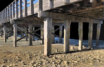
Unmanned aircraft systems (UAS, aka drones) are innovative tools quickly gaining acceptance as a standard technology in obtaining the imagery and point cloud data used in these models. Pre-planned missions using manual or autonomous flight controls can be used to capture imagery from the same point of view every time. This allows owners to perform periodic missions to track asset conditions and establish a much more complete record and deterioration profile for an asset. Recent technology has even put this capability right in the user’s pocket, literally! Figure 1 shows a reality model created using imagery captured using an iPhone 10.
This model was created as a proof of concept using a new application called Pix4Dcatch. Collins was able to identify locations where follow-up timber testing was to be performed, as well as obtain general inspection access and condition details, such as vertical under clearance and relative pile dimensions in their as-inspected conditions.

Figure 1. Reality model of a timber bridge in Duxbury, MA
Reality models organize significant amounts of data captured in a short period of time into a digital record that becomes part of the asset file. Models can be annotated with measurements and inspection findings and shared between staff in various departments. Additionally, reality models can be used during follow-up operations like maintenance, repair, and replacement activities. Owners and contractors can navigate the models from their desks during the planning, design, and construction phases to assist them in determining details like material quantities, site constraints, and equipment access as if they were in the field.
As technology advances, so does the ability of owners to achieve more detailed models with everyday tools. For example, the newest release of the Apple iPhone and iPad are equipped with a LiDAR sensor that provides enhanced ability to capture detailed data leading to more refined and accurate reality models.
Artificial Intelligence
Artificial intelligence (AI) is not a new concept and is becoming more prevalent in our daily lives in uses such as self-driving and parking cars, digital assistants like Siri and Alexa, and even robot vacuums. Recent advancements in AI technology have led to the development of useful applications for AI in the engineering industry and for asset management.
Computer vision is a field of AI that trains computers to interpret and understand the visual world. Using low cost digital images from cameras and videos in conjunction with machine learning models, computers can identify and classify objects through pixel matching. This technology can be used to assist with identifying asset deficiencies and through monitoring of cyclical imagery, computers can be trained to assess changes over time. Another example of this technology is in the automation of linework development in engineering plans. Using this pixel matching technology, AI-enabled software has been created to generate linework such as topography, edge of pavement, and building perimeters.
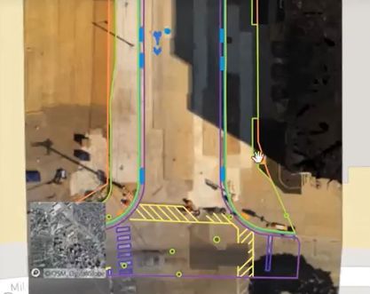
Collins is currently working with industry-leading companies on developing AI-enabled software for uses such as crack detection in concrete and automated mapping. One such collaboration is with Boston-based company AirWorks, which is using its innovative AI-enabled software to develop linework for engineering plans on a bridge replacement project in Massachusetts. Figure 2 shows an example of linework developed from aerial imagery captured using a drone. The various line colors represent different features, much like in a typical CAD\DXF file, and were created using AirWork’s proprietary software. Much like with reality modeling, the accuracy of the linework is dependent on the accuracy of the imagery and needs to be considered when planning to use this technology.

Figure 2. Linework for a roadway project using AirWork’s AI-enabled software
The use of this technology allows owners to more effectively manage resources for asset maintenance and utilize their personnel more efficiently on projects. Their knowledge and skillset can be better employed on more important activities, such as quality control and assurance.
Underwater Imaging
How can you effectively convey condition assessment findings for something you can’t see, even when it’s in front of your face? A large portion of this nation’s infrastructure is located under, over, or along the waterfront, whether along the coastal or inland waterways. With the increasing understanding of the impacts of sea level rise and the need for storm hardening, it’s becoming even more important that owners know and understand how to best manage their waterfront assets.
Since 1979, Collins has been helping owners with this challenge, having pioneered the use of professional engineer dive inspectors for condition assessments of underwater structures. Though an effective means for assessments, Collins’ years of experience have proven it’s not always as simple as placing a diver in the water. Water conditions such as depth, current, and clarity all play a role in the means and methods required to effectively assess underwater structures. For nearly 30 years, Collins has been utilizing underwater acoustic imaging equipment to supplement hands-on structural assessments, having first used it in 1991 during the failure investigation of the Lacey V. Murrow Floating Bridge for Washington DOT. This is where Collins began developing its technical skills within the growing field of reality modeling.
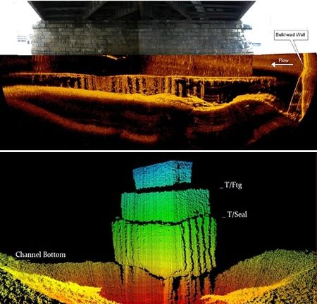
Using specialized sonar equipment, acoustic sound waves are produced and received underwater, much like LiDAR scanning above water, and a point cloud of the sound data can be modeled to produce 2-D and 3-D images of underwater structures. Figures 3a and 3b show models developed using various types of underwater acoustic imaging techniques.

Figure 3a (top). 2-D imaging of Washington Street Bridge, Boston, MA
Figure 3b (bottom). 3-D imaging of undermined pier with
exposed piles in South Carolina
This innovative technology has demonstrated value to owners with its ability to better define existing conditions. Users can perform quantitative measurements of structural configurations, deficiencies, and scour depressions using these models, which has proven to be very useful during the design phase for engineers and the construction phase for contractors. Pairing this with above-water imagery provides a complete picture of an asset, providing owners an unparalleled understanding of their waterfront infrastructure. This is a true win-win scenario for all parties involved in rehabilitation work for underwater structures, which historically carry a significant amount of risk to both owners and contractors due to unknown conditions.
Closing
We know our country is faced with a difficult challenge in managing its aging infrastructure, compounded with the expectation of doing more with constrained resources. Innovative technologies such as the three discussed in this article challenge the way we have always done things. However, these technologies are available today to help owners make more informed decisions while managing their assets for a safer and more reliable tomorrow.