Standing up to Extreme Storms: Federal Products to Support Coastal Emergency Preparedness and Resilience
By Brian Caufield, PE, CFM, PMP, D.CE, Principal, Coastal Systems Resilience Discipline Lead, CDM Smith and Tim Adams, Water Resources Engineer, CDM Smith
Are you ready for this? What do we expect from 2021 in comparison to 2020? Not only did we have to deal with a pandemic, but the Atlantic hurricane season included 31 total cyclones, naming 30 of them. Of the named storms, 14 became hurricanes and 11 made landfall in the U.S. This broke a record standing since 1916 of 9 landfalling hurricanes. The response of communities to these events depended upon if they were prepared for them. Many of the response activities to these events were virtual as communities dealt not only with damage to their facilities, but also the impacts of the pandemic.
We usually think of the Hurricane Season as June 1st through the end of October, but storms have been forming in the Atlantic and Pacific basins earlier each year. In 2021 we have already hit the first named storm prior to June 1st. It should come as no surprise that the prediction for 2021 is another active hurricane season. NOAA predicts 13-20 named storms, 6-10 hurricanes, and 3-5 major hurricanes. As we start the 2021 hurricane season, I ask that readers think about their own evacuation plans. Are you prepared to evacuate due to an oncoming storm? The Federal Government has a website where one can view the types of supplies to include in an emergency disaster kit.
Although extreme storms are on the rise, there are more and more resources being provided by Federal and State agencies for communities to evaluate the risks they face. While trying to avoid analysis paralysis, especially at times when efficient and effective decisions are necessary, many of these resources can be used in developed preparedness plans.
U.S. Geological Survey (USGS) has been developing new products related to shoreline erosion and coastal vulnerability. There are two websites that are currently in use and provide information related to coastal hazards: the USGS "Coastal Change Hazards Portal" and the "Total Water Level and Coastal Change Forecast Viewer".
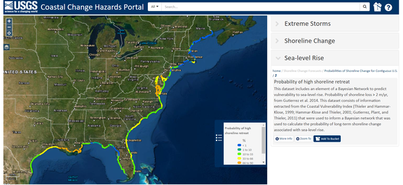
The USGS Coastal Change Hazards Portal acts as a central hub for a variety of coastal resources provided by the USGS. First, this website provides information related to probabilities of a storm type (hurricanes, Nor’easters, or real-time storm forecasting) resulting in collision (water levels and waves hitting the dune), overwash (waves overtopping the dune), and inundation (water levels inundating the dune). Perusing the forecast of the historic storms shows how valuable a tool these forecasts can be. Second, this website is also the host of the National Assessment of Shoreline Change studies, which those of us in Massachusetts can use to access the data by viewing the Massachusetts Shoreline Change Program. Finally, there is also information on the website relative to expectant changes to shorelines relative to sea level change (Figure 1). It is not a sea level rise viewer but rather provides estimates of what may be the changes to the shorelines under sea level rise.

Figure 1 – USGS Coastal Change Hazards Portal
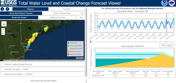
USGS has also developed a tool called the Total Water Level and Coastal Change Forecast Viewer, shown in Figure 2. A portion of the New England coastline is within this experimental product. The data provided in this viewer are similar to those in the Coastal Change Hazards Portal (collision, overwash, and inundation), but is provided as profile-based results. The model outputs show a time series interaction of the profile with the predicted water level and total water level over the course of the forecast.

Figure 2 – USGS Total Water Level and Coastal Change Forecast Viewer
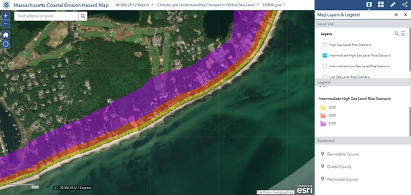
Federal Emergency Management Agency (FEMA) has also been developing a new, non-regulatory product to help communities understand their long-term risk to coastal erosion. The Coastal Erosion Hazard Map presents estimated areas at risk from coastal erosion by 2030, 2050 and 2100 under a variety of NOAA sea level rise scenarios (Figure 3). The analysis, led by Compass, a joint-venture between CDM Smith and AECOM, considers both historical rates of erosion and the acceleration of coastal erosion due to increasing sea level rise. Different shore types such as beaches or tall bluffs are analyzed using different methods so that the results present location-specific estimates of the potential for shoreline retreat. Several counties in Massachusetts are already complete and most of New England is in development.

Figure 3 – FEMA Coastal Erosion Hazard Map
When properly used, products such as those discussed above can provide awareness of risk and inform future mitigation projects. Mitigation is an important tool to reduce risk and should be incorporated continuously to be effective. Often, investment in mitigation design and planning is a challenge to identify due to other civic priorities. However, it has been estimated that $1 of mitigation investment results in $6 of reduced damages. In 2020, FEMA had its first ever round of Building Resilient Infrastructure and Communities grants and President Biden recently announced increasing the $500M available in 2020 to $1B available in 2021. FEMA also provides the Pre-Disaster Mitigation Grant Program to assist States, territories, Federally-recognized tribes and local communities in implementing sustained pre-disaster natural hazard mitigation programs. The Commonwealth of Massachusetts also has grant programs such as the Municipal Vulnerability Program and the Coastal Zone Management Grants.
More hurricanes made landfall in the U.S. last year than any year before. These and other extreme storms present risks to communities that require a thoughtful, informed approach to manage those risks and prepare for the worst. Federal and state agencies are providing mitigation grants and developing a variety of coastal products to support these efforts. As engineers and community members, we have an opportunity to strengthen our neighborhoods as we prepare for the next 2020.