The Benefits of Artificial Intelligence for Pavement Management
By: Alison McGee, RoadBotics and Bill Scully, P.E., Green International Affiliates
Over the past few years, Artificial Intelligence (AI)-based technologies have begun to emerge in the Civil Engineering industry. Although AI is not equipped to address many aspects of Civil Engineering, the technologies have proven successful in optimizing design, managing risk, monitoring safety, and automating inspections and assessments. For civil engineers, they are beneficial tools for increasing productivity and improving overall efficiency, and conserving resources including manpower, time, money, and materials.
One area that benefits greatly from a technological approach is pavement management. RoadBotics, a Pittsburgh-based technology company, is revolutionizing the first step of pavement management planning by automating pavement assessments using AI. ASCE awarded RoadBotics five honors in 2018, including the Greatest Impact on Delivery the ASCE Grand Challenge Award.
In 2017, RoadBotics formed a partnership with Massachusetts-based Civil Engineering firm Green International Affiliates (Green) to bring the AI and machine learning (ML) pavement management method to New England. One benefit of using AI for data collections and initial assessments is the objectivity in the data collected. The computer “eye” is consistent in its view of the pavement surface, in contrast to manual inspection where multiple technicians collect and interpret the information, which often results in contradicting viewpoints and subjectivity.
Green’s method begins with a RoadBotics’ automated assessment to provide pavement surface condition data. The process starts with data collection using a smartphone that is mounted to a vehicle’s windshield. The phone collects video footage of the road as a user drives the network. The footage is then fed through a vision-based ML model, a subset of AI, to identify road distresses and assign condition ratings on a 1 to 5 scale.

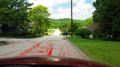
Figure 1. Image of Roadbotics Machine
Learning Pavement Assessment
The model is trained by feeding thousands of manually labeled and rated road images into an Artificial Deep Neural Network designed by RoadBotics’ data scientists. As with all vision-based ML models, it becomes increasingly more accurate as it processes additional images over time. RoadBotics’ technology is also advanced enough to identify various types of pavement distresses within the road network including potholes, fatigue cracking, and surface deterioration. Figure 1 illustrates how the ML model interprets fatigue cracking.
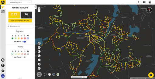
After the analysis is complete, the engineers and clients access their road network results on RoadWay, RoadBotics’ proprietary GIS pavement assessment platform. On RoadWay, users view and manage their network results on a color-coded map with conditionally rated road imagery every ten feet.

Figure 2. Town of Ashland Viewed on RoadWay
This granularity is vital to pavement design engineers, who can review and confirm the assessment, pinpoint precise locations for maintenance and improvements, and utilize the pavement data to develop treatment plans.
Green’s decision to adopt RoadBotics’ technology into their pavement management strategy was rooted in the acknowledgment that, as civil engineers, it is important to embrace and utilize new and emergent technologies.
Green’s Vice President Bill Scully explains, “use of these tools together with engineering know-how and judgment allows us to be responsive to the needs of the municipal client and general public to get something productive done efficiently, safely, and with pragmatism.”
After the initial vetting of the process and results, Green’s pavement engineers found RoadBotics’ approach to be efficient, accurate, and objective. The resulting data provided “sufficient levels of information to make sound decisions for determining pavement treatments and developing priorities,” explained Mr. Scully.
Green’s portfolio of clients includes small to medium-size communities in New England that have limited manpower, resources, and budgets. RoadBotics’ technology streamlines the assessment process and provides objective, actionable data for easy analysis and plan development.
For example, Green’s engineers can collect data for an 80 to 100-mile road network in just two or three days. And within 45 days, they can be finalizing assessments, developing potential treatments, and calculating preliminary costs. With other methods, municipal officials may have to wait 6 to 12 months to receive that information.
One of Green’s municipal clients is the Town of Ashland, Massachusetts, a suburban community located approximately 30 miles west of Boston. In 2019, Green completed a pavement management plan for Ashland’s 80-mile road network using their AI pavement management method.
In just two days, the pavement data was collected for the entire network using RoadBotics smartphone applications. Previously, the Department of Public Works (DPW) Director and staff would spend weeks driving the network to look at the roads and manually collect pavement condition information. When addressing the feasibility of manual inspections, Ashland’s DPW Director, Doug Small, explained that “most cities and towns the size of Ashland don’t have that luxury.”
After the data was collected and analyzed, it was uploaded to RoadWay for Green engineers and Ashland officials to utilize, displayed in Figure 2. The individual point-level data ratings are aggregated to form the overall network score - in Ashland’s case, the road network was in “fair” condition with a network score of 2.68.
Green’s engineers reviewed the data and conducted selective field checks to confirm the ML results, as well as obtain additional information essential in determining a recommended treatment. To remain consistent with their data-oriented pavement planning process, Green’s engineers were able to relate the RoadBotics’ ratings to a corresponding Pavement Condition Index (PCI) value range with recommended rehabilitation measures, as shown in Figure 3. PCI is one common measure used to describe the pavement surface condition.

Figure 3. Green's Condition and Treatment Table
The resulting five-year pavement management plan for Ashland included four budget planning scenarios that Green International created based on the pavement condition ratings, rehabilitation recommendations, and estimated budget. The scenarios estimated changes in the overall network score expected from varying degrees of intervention and investment for Ashland’s DPW officials to consider. The cost effectiveness of applying the AI technology allows the municipal engineers to better and more consistently manage their road system.
Overall, the AI pavement management approach is beneficial for DPW officials because it is an efficient, accurate, and budget-friendly alternative to other methods. “The combination of RoadBotics working with Green International, it’s like peanut butter and jelly,” explains Mr. Small. “They definitely complement each other. It’s perfect.”